
1958 Map of Fairmont
USGS Topo · Published 1958About this map
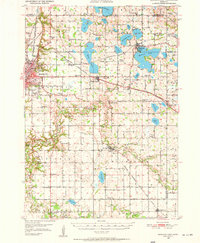
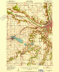
Fairmont Municipal and the surrounding prairie landscape define this 1950s survey of southern Minnesota and northern Iowa. The region is characterized by an extensive network of railroads, including the Chicago Milwaukee St Paul and Pacific and the Chicago and North Western, which connect agricultural hubs like Worthington and Spencer. A striking concentration of glacial lakes sits at the state border, anchored by Spirit Lake and Okoboji Lake, where the Lakeside Laboratory is situated.
Find a feature on this map
261 named features on this map. Tap any name to fly to it.
Don’t see what you’re looking for? This feature index may not catch every label — zoom into the map to look around manually.
Map Details
Editions of this 1958 Fairmont Map
This is the sole edition of this map. No revisions or reprints were ever made.
Other maps of this area
1950 · Mankato East
USGS Topo · 1:62,500

1951 · Mankato East
USGS Topo · 1:62,500
1951 · Mankato West
USGS Topo · 1:62,500

1953 · Saint Paul
USGS Topo · 1:250,000

1953 · Watertown
USGS Topo · 1:250,000

1953 · New Ulm
USGS Topo · 1:250,000

1954 · Fairmont
USGS Topo · 1:250,000

1954 · Mason City
USGS Topo · 1:250,000

1954 · Waterloo
USGS Topo · 1:250,000

1954 · Fort Dodge
USGS Topo · 1:250,000