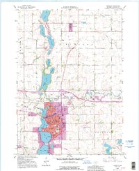
1992 Map of Fairmont
USGS Topo · Published 1995About this map
Fairmont's distinctive chain of lakes—including George Lake, Sisseton Lake, Budd Lake, and Hall Lake—dominates this Martin County landscape, showing the city's growth around these central water bodies. The 1990s revisions highlight urban developments such as the Fairmont Municipal Airport and Interchange 102, while maintaining the historical grid of the central business district and civic institutions like the Jr High Sch and High Sch. North of the city, the small settlement of Northrop sits along the Old Grade Railroad, surrounded by a meticulously ditched agricultural landscape defined by Judicial Ditch No 8 and Judicial Ditch No 48. The map documents numerous local landmarks of value to genealogists, from the Lakeside Cemetery on the lakefront to the Immanuel Cem and parochial institutions like St Paul Sch.
Find a feature on this map
59 named features on this map. Tap any name to fly to it.
Don’t see what you’re looking for? This feature index may not catch every label — zoom into the map to look around manually.
Map Details
Editions of this 1992 Fairmont Map
This is the sole edition of this map. No revisions or reprints were ever made.
Other maps of this area

1954 · Fairmont
USGS Topo · 1:250,000

1958 · Fairmont
USGS Topo · 1:250,000

1967 · Truman
USGS Topo · 1:24,000

1967 · East Chain
USGS Topo · 1:24,000

1967 · Wilmert Lake
USGS Topo · 1:24,000

1967 · Truman SE
USGS Topo · 1:24,000

1967 · Granada
USGS Topo · 1:24,000

1967 · Fairmont
USGS Topo · 1:24,000

1970 · St James SE
USGS Topo · 1:24,000

1970 · Welcome
USGS Topo · 1:24,000