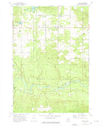
1972 Map of Fairview
USGS Topo · Published 1975About this map
The Au Sable River cuts a wide, meandering path through the heart of this central Oscoda County landscape, separating the townships of Comins and Mentor. In the early 1970s, this region remained heavily defined by the vast timberlands of the Huron National Forest and Oscoda State Forest. The settlement of Fairview serves as a local hub in the north, while the village of Mio occupies the southwest corner near the river's edge. Traces of the region's logging and transport history are evident in the numerous corridors labeled Old Railroad Grade and Private Railroad, which once moved timber through the dense woods. Smaller settlements like Kneeland and localized landmarks such as the Mio Airport and Weaver Cem provide specific points of interest for genealogists tracing family footprints in this rural Michigan woodland.
Find a feature on this map
41 named features on this map. Tap any name to fly to it.
Don’t see what you’re looking for? This feature index may not catch every label — zoom into the map to look around manually.
Map Details
Editions of this 1972 Fairview Map
2 editions found
Other maps of this area

1954 · Traverse City
USGS Topo · 1:250,000

1954 · Tawas City
USGS Topo · 1:250,000

1955 · Comins
USGS Topo · 1:62,500

1958 · Traverse City
USGS Topo · 1:250,000

1958 · Tawas City
USGS Topo · 1:250,000

1972 · McKinley
USGS Topo · 1:24,000

1972 · McCollum Lake
USGS Topo · 1:24,000

1972 · Goodar
USGS Topo · 1:24,000

1972 · Mio
USGS Topo · 1:24,000

1972 · Mack Lake
USGS Topo · 1:24,000