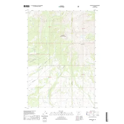
2020 Map of Fairview Peak
USGS Topo · Published 2020About this map
Fairview Peak dominates this high-altitude landscape along the border of Park Co and Sweet Grass Co, within the protected bounds of the Gallatin National Forest. The map documents a complex drainage system where the headwaters of S Fork Big Timber Cr and Rock Creek carve through steep terrain. While much of the land remains undeveloped forest, the lower elevations show signs of agricultural and ranching infrastructure. Robinson Bench and the associated Robinson Bench Rd indicate human adaptation to the geography, while the presence of the Bishir Ditch and the Cottonwood Lowline route suggests historical water management and access for grazing or timber. Remote water bodies like Smeller Lake and Swamp Lake are shown in their natural state, serving as landmarks for those navigating the backcountry of south-central Montana.
Find a feature on this map
39 named features on this map. Tap any name to fly to it.
Don’t see what you’re looking for? This feature index may not catch every label — zoom into the map to look around manually.
Map Details
Editions of this 2020 Fairview Peak Map
This is the sole edition of this map. No revisions or reprints were ever made.
Other maps of this area

1886 · Little Belt Mts.
USGS Topo · 1:250,000

1891 · Livingston
USGS Topo · 1:250,000

1893 · Livingston
USGS Topo · 1:250,000

1894 · Little Belt Mts.
USGS Topo · 1:250,000

1897 · Little Belt Mts.
USGS Topo · 1:250,000

1898 · Little Belt Mts.
USGS Topo · 1:250,000

1902 · Little Belt Mts.
USGS Topo · 1:250,000

1947 · Bozeman
USGS Topo · 1:250,000

1948 · Bozeman
USGS Topo · 1:250,000

1948 · White Sulphur Springs
USGS Topo · 1:250,000