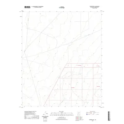
2020 Map of Fairview Well
USGS Topo · Published 2020About this map
Arid Sierra County highlands define this landscape, where a sparse network of ranch roads and water catchment basins supports life in the high desert. Naval Site Rd and Co Rd A-27 provide the primary access through this terrain, connecting remote ranching infrastructure. The placement of named water sources like Antelope Tank, Keene Tank, and Waterhole Tank reveals a long-standing reliance on surface water management for livestock and land use. These features, along with Big Tank and Hayfield Tank, indicate the vital role of specific topography in sustaining human activity in this part of New Mexico, where roads like E Well Rd trace the path of essential utility and communication across the desert flats and ridges.
Find a feature on this map
14 named features on this map. Tap any name to fly to it.
Don’t see what you’re looking for? This feature index may not catch every label — zoom into the map to look around manually.
Map Details
Editions of this 2020 Fairview Well Map
This is the sole edition of this map. No revisions or reprints were ever made.
Other maps of this area

1916 · Salinas Peak
USGS Topo · 1:125,000

1948 · Sowell
USGS Topo · 1:62,500

1948 · Malpais Well
USGS Topo · 1:62,500

1954 · Tularosa
USGS Topo · 1:250,000

1958 · Tularosa
USGS Topo · 1:250,000

1959 · Engle
USGS Topo · 1:62,500

1961 · Crocker
USGS Topo · 1:24,000

1961 · Lava
USGS Topo · 1:24,000

1979 · Truth or Consequences
USGS Topo · 1:100,000
1981 · Shannon Canyon
USGS Topo · 1:24,000