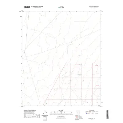
2023 Map of Fairview Well
USGS Topo · Published 2023About this map
Water management dominates this arid landscape in Sierra County, as evidenced by a network of cattle tanks distributed across the township boundaries. These localized water sources, including Antelope Tank, Keene Tank, and Waterhole Tank, are critical nodes for the ranching operations that have long defined the region. Sparse transportation infrastructure connects these points, with Naval Site Rd and Co Rd A-27 providing the primary access through the desert terrain. The map reveals a highly structured legal landscape, where the intersections of t11s r1w, t11s r1e, t12s r1w, and t12s r1e form a nexus of land divisions. Smaller features like AAA Tank and Big Tank further illustrate the reliance on collected runoff in a territory where permanent natural streams are absent, reflecting the enduring practicalities of high-desert land use.
Find a feature on this map
14 named features on this map. Tap any name to fly to it.
Don’t see what you’re looking for? This feature index may not catch every label — zoom into the map to look around manually.
Map Details
Editions of this 2023 Fairview Well Map
This is the sole edition of this map. No revisions or reprints were ever made.
Other maps of this area

1916 · Salinas Peak
USGS Topo · 1:125,000

1948 · Sowell
USGS Topo · 1:62,500

1948 · Malpais Well
USGS Topo · 1:62,500

1954 · Tularosa
USGS Topo · 1:250,000

1958 · Tularosa
USGS Topo · 1:250,000

1959 · Engle
USGS Topo · 1:62,500

1961 · Crocker
USGS Topo · 1:24,000

1961 · Lava
USGS Topo · 1:24,000

1979 · Truth or Consequences
USGS Topo · 1:100,000
1981 · Shannon Canyon
USGS Topo · 1:24,000