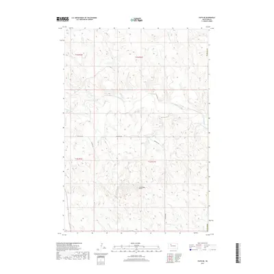
2017 Map of Faith NE
USGS Topo · Published 2017About this map
The Moreau River meanders across the northern plains of Ziebach and Perkins counties, creating a complex drainage network in this section of South Dakota. The topography is defined by the sharp rise of Arrowhead Butte, a prominent landmark that breaks the surrounding horizon near the intersection of Arrowhead Rd and Flint Rock Rd. Numerous seasonal watercourses including Berry Cr, Badlands Cr, and Locate Cr carve through the landscape, illustrating the erosive patterns common to this arid region. The map highlights the sparse infrastructure of the modern era, where long-established section lines and unpaved routes like Badlands Rd provide the primary access through the open range and agricultural allotments of the t14n r17e and t15n r17e townships.
Find a feature on this map
15 named features on this map. Tap any name to fly to it.
Don’t see what you’re looking for? This feature index may not catch every label — zoom into the map to look around manually.
Map Details
Editions of this 2017 Faith NE Map
This is the sole edition of this map. No revisions or reprints were ever made.
Other maps of this area

1951 · Redelm NW
USGS Topo · 1:24,000

1951 · Faith NE
USGS Topo · 1:24,000

1952 · Faith NW
USGS Topo · 1:24,000

1953 · McIntosh
USGS Topo · 1:250,000

1954 · Lemmon
USGS Topo · 1:250,000

1957 · Lemmon
USGS Topo · 1:250,000

1958 · McIntosh
USGS Topo · 1:250,000

1982 · Glad Valley SW
USGS Topo · 1:24,000
1982 · Red Elm SW
USGS Topo · 1:24,000
1983 · Faith
USGS Topo · 1:24,000