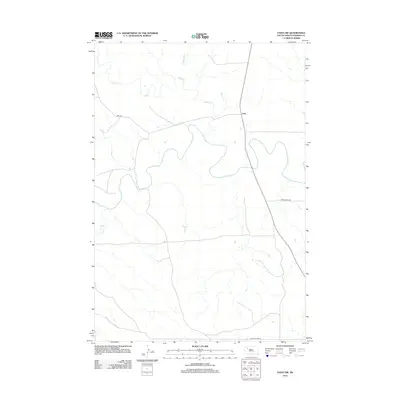
2012 Map of Faith NW
USGS Topo · Published 2012About this map
Usta serves as the primary focal point of this western South Dakota landscape, situated at the intersection of S Dakota Hwy 73 and Usta Rd. The terrain is defined by the winding course of the Moreau River, which meanders through the central and southern portions of the quadrangle. This prairie environment is further articulated by a network of seasonal watercourses, including Rabbit Cr in the north, Porcupine Cr, and Deep Cr. The road network, featuring routes like Arrowhead Rd, provides a clear view of the rural infrastructure and land management patterns in Perkins County during the early 21st century. This survey documents the persistent relationship between sparse high-plains settlements and the vital river systems that anchor them.
Find a feature on this map
8 named features on this map. Tap any name to fly to it.
Don’t see what you’re looking for? This feature index may not catch every label — zoom into the map to look around manually.
Map Details
Editions of this 2012 Faith NW Map
This is the sole edition of this map. No revisions or reprints were ever made.
Other maps of this area

1951 · Faith NE
USGS Topo · 1:24,000

1952 · Deep Creek SE
USGS Topo · 1:24,000

1952 · Deep Creek NE
USGS Topo · 1:24,000

1952 · Faith NW
USGS Topo · 1:24,000

1954 · Lemmon
USGS Topo · 1:250,000

1957 · Lemmon
USGS Topo · 1:250,000
1983 · Faith
USGS Topo · 1:24,000

1983 · Sunrise Butte
USGS Topo · 1:24,000

1983 · Coal Springs SW
USGS Topo · 1:24,000
1983 · Coal Springs SE
USGS Topo · 1:24,000