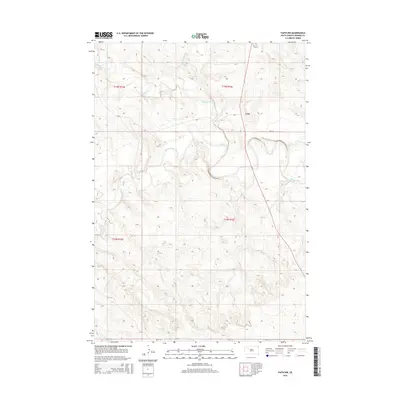
2015 Map of Faith NW
USGS Topo · Published 2015About this map
Usta occupies a central position in this prairie landscape, situated near the intersection of CR-8 and South Dakota Highway 73. The geography is defined by the winding course of the Moreau River, which meanders across the central portion of the quadrangle, carving complex drainages into the Perkins County terrain. These waterways, including Rabbit Cr and Porcupine Cr to the north, along with Deep Cr to the south, indicate a drainage pattern focused on the river's basin. The map reveals a sparse settlement pattern characteristic of the western South Dakota plains, where vast sections of land are punctuated primarily by county roads like CR-15 and section lines. This 2015 survey provides a modern look at the rural infrastructure and natural hydrology that continue to shape the community of Usta and its surrounding ranchlands.
Find a feature on this map
14 named features on this map. Tap any name to fly to it.
Don’t see what you’re looking for? This feature index may not catch every label — zoom into the map to look around manually.
Map Details
Editions of this 2015 Faith NW Map
This is the sole edition of this map. No revisions or reprints were ever made.
Other maps of this area

1951 · Faith NE
USGS Topo · 1:24,000

1952 · Deep Creek SE
USGS Topo · 1:24,000

1952 · Deep Creek NE
USGS Topo · 1:24,000

1952 · Faith NW
USGS Topo · 1:24,000

1954 · Lemmon
USGS Topo · 1:250,000

1957 · Lemmon
USGS Topo · 1:250,000
1983 · Faith
USGS Topo · 1:24,000

1983 · Sunrise Butte
USGS Topo · 1:24,000

1983 · Coal Springs SW
USGS Topo · 1:24,000
1983 · Coal Springs SE
USGS Topo · 1:24,000