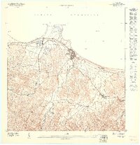
1947 Map of Fajardo NO
USGS Topo · Published 1948About this map
Coastal sugar production and railway logistics dominate this late 1940s survey of the northeastern Puerto Rican shore. Luquillo is the primary urban center, situated between the Océano Atlántico and a landscape of concentrated agricultural estates. The prevalence of named agricultural colonies, such as Colonia Monserrate, Colonia San Miguel, and Colonia Margarita, indicates a land-use pattern focused on large-scale sugarcane cultivation. These estates are connected by the infrastructure of the Fajardo Development Company, whose narrow-gauge railroad lines thread through the lowlands to move crops toward the port.
Find a feature on this map
17 named features on this map. Tap any name to fly to it.
Don’t see what you’re looking for? This feature index may not catch every label — zoom into the map to look around manually.
Map Details
Editions of this 1947 Fajardo NO Map
This is the sole edition of this map. No revisions or reprints were ever made.
Other maps of this area

1941 · Rio Grande
USGS Topo · 1:30,000

1945 · El Yunque
USGS Topo · 1:30,000

1946 · El Yunque
USGS Topo · 1:30,000

1946 · Fajardo
USGS Topo · 1:30,000

1947 · El Yunque NE
USGS Topo · 1:10,000

1947 · Rio Grande
USGS Topo · 1:30,000

1947 · Fajardo NE
USGS Topo · 1:10,000
1950 · Rio Grande SE
USGS Topo · 1:10,000
1952 · El Yunque
USGS Topo · 1:30,000
1952 · Fajardo
USGS Topo · 1:30,000