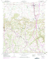
1949 Map of Falkville
USGS Topo · Published 1983About this map
Falkville serves as the primary hub in this mid-century portrait of the north Alabama corridor where the Louisville and Nashville railroad tracks parallel the rising slopes of Brindley Mountain. The landscape is a mix of small agricultural settlements and natural landmarks, featuring several hilltop churches like Roundtop Ch and Fairview Ch. To the south, the terrain becomes more complex as the Divide separates the drainage of Indian Creek from the Milligan Cove area. Notable local landmarks include Saltpeter Cave and Indian Cave tucked into the mountain's eastern face, while the valley floor shows specialized land uses such as the minnow rearing pools near the Morgan Co Cullman Co line. This survey captures a moment of transition, showing the intersection of traditional community centers like Ebenezer Sch with the burgeoning interstate highway system indicated by purple revisions.
Find a feature on this map
65 named features on this map. Tap any name to fly to it.
Don’t see what you’re looking for? This feature index may not catch every label — zoom into the map to look around manually.
Map Details
Editions of this 1949 Falkville Map
4 editions found

Other maps of this area

1888 · Cullman
USGS Topo · 1:125,000

1892 · Cullman
USGS Topo · 1:125,000

1927 · Falkville
USGS Topo · 1:24,000

1935 · Danville
USGS Topo · 1:48,000

1936 · Mc Kendry
USGS Topo · 1:24,000

1936 · Hartselle
USGS Topo · 1:24,000

1936 · Eva
USGS Topo · 1:24,000

1936 · Somerville
USGS Topo · 1:24,000

1936 · Stroups Crossroads
USGS Topo · 1:24,000

1938 · Danville
USGS Topo · 1:62,500