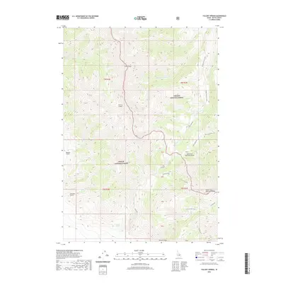
2020 Map of Fallert Springs
USGS Topo · Published 2020About this map
The high ridges of the Lemhi Range dominate this Idaho landscape, where the boundary between the Targhee National Forest and Challis National Forest meets. Mining history is evident in the south, particularly near Mormon Gulch, where the Mormon Gulch Mines are located. Further north, the Uncle Ike Mines sit along the upper reaches of Uncle Ike Cr, illustrating the extraction history typical of these steep drainages.
Find a feature on this map
27 named features on this map. Tap any name to fly to it.
Don’t see what you’re looking for? This feature index may not catch every label — zoom into the map to look around manually.
Map Details
Editions of this 2020 Fallert Springs Map
This is the sole edition of this map. No revisions or reprints were ever made.
Other maps of this area

1955 · Dubois
USGS Topo · 1:250,000

1955 · Idaho Falls
USGS Topo · 1:250,000

1957 · Diamond Peak
USGS Topo · 1:62,500

1958 · Dubois
USGS Topo · 1:250,000

1958 · Idaho Falls
USGS Topo · 1:250,000

1969 · Eightmile Canyon
USGS Topo · 1:24,000

1969 · Tyler Peak
USGS Topo · 1:24,000

1969 · Howe NW
USGS Topo · 1:24,000

1969 · Howe NE
USGS Topo · 1:24,000
1969 · Blue Dome
USGS Topo · 1:24,000