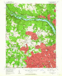
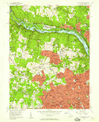
1956 Map of Falls Church
USGS Topo · Published 1961About this map
The Potomac River corridor dominates this mid-century landscape, serving as a boundary between Maryland and Virginia while hosting the historic Chesapeake and Ohio Canal. To the south, the rapid post-war expansion of Northern Virginia is evident in the sprawling residential developments surrounding the City of Falls Church and McLean. This era represents a significant transformation of formerly rural Fairfax County into a suburban engine, yet traces of an older agricultural past remain in labels for Fawcett Farms and Swinks Mill.
Find a feature on this map
220 named features on this map. Tap any name to fly to it.
Don’t see what you’re looking for? This feature index may not catch every label — zoom into the map to look around manually.
Map Details
Editions of this 1956 Falls Church Map
2 editions found
Other maps of this area

1890 · Mt. Vernon
USGS Topo · 1:125,000

1891 · Mt. Vernon
USGS Topo · 1:125,000

1893 · Frederick
USGS Topo · 1:125,000

1894 · Frederick
USGS Topo · 1:125,000

1894 · Mt. Vernon
USGS Topo · 1:125,000

1897 · Mt. Vernon
USGS Topo · 1:125,000

1900 · Washington
USGS Topo · 1:62,500

1908 · Rockville
USGS Topo · 1:62,500

1908 · Seneca
USGS Topo · 1:62,500

1915 · Fairfax
USGS Topo · 1:62,500