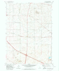
1979 Map of Falls City
USGS Topo · Published 1980About this map
Agricultural irrigation and transport infrastructure define this landscape between Jerome and the Snake River plain. The Union Pacific railroad cuts a straight line through the center of the sheet, connecting the small settlements of Falls City and Barrymore. This rail corridor is mirrored by an extensive network of unnamed Canal and Ditch lines that transformed the arid terrain of south-central Idaho into productive farmland during the mid-20th century. Highlighting the local utility and aviation history, the County Airport and the Radio Tower (KMVT) on Flat Top Butte serve as prominent landmarks. Geologic extraction is evident in the numerous Gravel Pits and a Borrow Pit scattered near the road junctions, while the southern portion of the map reveals the early development of the interstate highway system with several designated Rest Area locations.
Find a feature on this map
22 named features on this map. Tap any name to fly to it.
Don’t see what you’re looking for? This feature index may not catch every label — zoom into the map to look around manually.
Map Details
Editions of this 1979 Falls City Map
This is the sole edition of this map. No revisions or reprints were ever made.
Other maps of this area

1950 · Filer
USGS Topo · 1:24,000

1950 · Jerome
USGS Topo · 1:24,000

1950 · Jerome
USGS Topo · 1:62,500

1955 · Twin Falls
USGS Topo · 1:250,000

1958 · Twin Falls
USGS Topo · 1:250,000

1964 · Kimberly
USGS Topo · 1:24,000

1964 · Falls City
USGS Topo · 1:24,000

1964 · Twin Falls
USGS Topo · 1:24,000

1964 · Perrine
USGS Topo · 1:24,000

1971 · Shoshone SE
USGS Topo · 1:24,000