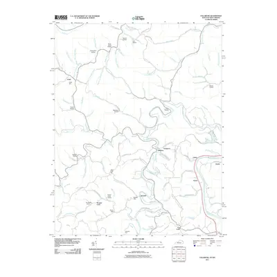
2011 Map of Fallsburg
USGS Topo · Published 2011About this map
Blaine Creek snakes through this Lawrence County landscape, punctuated by the engineering of the Yatesville Dam and the resulting waters near Yatesville. This 2011 survey captures the modern infrastructure and rural settlement patterns along the Big Sandy River corridor, which forms the boundary with West Virginia. The terrain is marked by numerous family-named hollows and hills, such as Grannyham Hollow, Sugar Camp Hollow, and Jerry Riffe Hill, reflecting generations of local land tenure. Smaller communities like Fallsburg, Stringtown, and Fullers are connected by a network of winding roads like Fallsburg Ridge RD. Notable landmarks for local history include the Patton Memorial Cemetery and prominent geological features like Raven Rock, illustrating the intersection of the region's topographical character and its social geography.
Find a feature on this map
110 named features on this map. Tap any name to fly to it.
Don’t see what you’re looking for? This feature index may not catch every label — zoom into the map to look around manually.
Map Details
Editions of this 2011 Fallsburg Map
This is the sole edition of this map. No revisions or reprints were ever made.
Other maps of this area

1901 · Ceredo
USGS Topo · 1:62,500

1903 · Kenova
USGS Topo · 1:125,000

1904 · Kenova
USGS Topo · 1:125,000

1911 · Louisa
USGS Topo · 1:48,000

1913 · Ceredo
USGS Topo · 1:62,500

1913 · Louisa
USGS Topo · 1:62,500

1939 · Louisa
USGS Topo · 1:62,500
1953 · Prichard
USGS Topo · 1:24,000

1953 · Rush
USGS Topo · 1:24,000

1953 · Boltsfork
USGS Topo · 1:24,000