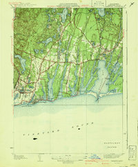
1941 Map of Falmouth
USGS Topo · Published 1941About this map
The glacial outwash plain of southern Falmouth is defined by a striking series of parallel north-south coastal ponds and inlets, including Great Pond, Green Pond, and Eel Pond. Surveyed in the mid-1930s, this landscape shows the established summer resort infrastructure of the era, from the waterfront developments at Falmouth Heights and Maravista to the more secluded settlements like Menauhant and Davisville. Inland, the terrain is dotted with numerous kettle ponds such as Coonamessett Pond and Jenkins Pond, interspersed with cranberry bogs and localized clusters of industry like the Fire Tower near Blacksmith Shop Road. Further east, the village of Waquoit Village sits at the head of Waquoit Bay, a significant maritime feature sheltered by Seconsett Island and Dead Neck. Local transit is centered on historic thoroughfares such as Sandwich Road and Meetinghouse Road, which connect the scattered coastal villages to the interior.
Find a feature on this map
63 named features on this map. Tap any name to fly to it.
Don’t see what you’re looking for? This feature index may not catch every label — zoom into the map to look around manually.
Map Details
Editions of this 1941 Falmouth Map
3 editions found
Other maps of this area

1886 · Falmouth
USGS Topo · 1:62,500

1887 · Marthas Vineyard
USGS Topo · 1:62,500

1888 · Barnstable
USGS Topo · 1:62,500

1888 · Falmouth
USGS Topo · 1:62,500

1889 · Marthas Vineyard
USGS Topo · 1:62,500

1893 · Barnstable
USGS Topo · 1:62,500

1893 · Falmouth
USGS Topo · 1:62,500

1894 · Marthas Vineyard
USGS Topo · 1:62,500

1915 · Falmouth
USGS Topo · 1:62,500

1920 · Falmouth
USGS Topo · 1:62,500