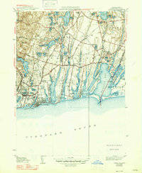
1941 Map of Falmouth
USGS Topo · Published 1947About this map
Glacial topography and coastal indentations define this 1940s landscape of Cape Cod, where numerous kettle ponds like Coonamessett Pond and Jenkins Pond dot the interior. The shoreline is characterized by a series of south-reaching peninsulas including Lewis Neck, Green Neck, and Davis Neck, which separate the long finger ponds from the larger Waquoit Bay. Inland, the agricultural and industrial character of the era is evident through the widespread presence of Cranberry Bogs situated in the low-lying wetlands between ridges.
Find a feature on this map
67 named features on this map. Tap any name to fly to it.
Don’t see what you’re looking for? This feature index may not catch every label — zoom into the map to look around manually.
Map Details
Editions of this 1941 Falmouth Map
3 editions found
Other maps of this area

1886 · Falmouth
USGS Topo · 1:62,500

1887 · Marthas Vineyard
USGS Topo · 1:62,500

1888 · Barnstable
USGS Topo · 1:62,500

1888 · Falmouth
USGS Topo · 1:62,500

1889 · Marthas Vineyard
USGS Topo · 1:62,500

1893 · Barnstable
USGS Topo · 1:62,500

1893 · Falmouth
USGS Topo · 1:62,500

1894 · Marthas Vineyard
USGS Topo · 1:62,500

1915 · Falmouth
USGS Topo · 1:62,500

1920 · Falmouth
USGS Topo · 1:62,500