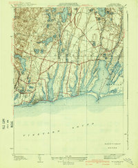
1941 Map of Falmouth
USGS Topo · Published 1941About this map
The coastal shelf of Cape Cod is defined by its distinctive glacial outwash ponds and long, finger-like salt ponds reaching toward Vineyard Sound. This 1936 survey, compiled in part from early aerial photographs, documents the transition between the established maritime hub of Falmouth and its outlying agricultural and residential hamlets. Along the southern coast, seasonal developments such as Falmouth Heights, Mara Vista, and Menauhant sit between Great Pond and Bowen Pond, illustrating the area's growth as a summer destination.
Find a feature on this map
70 named features on this map. Tap any name to fly to it.
Don’t see what you’re looking for? This feature index may not catch every label — zoom into the map to look around manually.
Map Details
Editions of this 1941 Falmouth Map
3 editions found
Other maps of this area

1886 · Falmouth
USGS Topo · 1:62,500

1887 · Marthas Vineyard
USGS Topo · 1:62,500

1888 · Barnstable
USGS Topo · 1:62,500

1888 · Falmouth
USGS Topo · 1:62,500

1889 · Marthas Vineyard
USGS Topo · 1:62,500

1893 · Barnstable
USGS Topo · 1:62,500

1893 · Falmouth
USGS Topo · 1:62,500

1894 · Marthas Vineyard
USGS Topo · 1:62,500

1915 · Falmouth
USGS Topo · 1:62,500

1920 · Falmouth
USGS Topo · 1:62,500