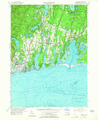
1957 Map of Falmouth
USGS Topo · Published 1965About this map
Coonamessett Pond and Jenkins Pond anchor the northern interior of this Upper Cape landscape, where the town of Falmouth meets Mashpee. The map details a period of mid-century coastal development, particularly evident in the street grids of Falmouth Heights and Mara Vista fronting Vineyard Sound. Cultural landmarks like the Drive-in Theater near Teaticket and the High Sch provide a glimpse into the local community during the late 1950s.
Find a feature on this map
77 named features on this map. Tap any name to fly to it.
Don’t see what you’re looking for? This feature index may not catch every label — zoom into the map to look around manually.
Map Details
Editions of this 1957 Falmouth Map
3 editions found
Other maps of this area

1886 · Falmouth
USGS Topo · 1:62,500

1887 · Marthas Vineyard
USGS Topo · 1:62,500

1888 · Barnstable
USGS Topo · 1:62,500

1888 · Falmouth
USGS Topo · 1:62,500

1889 · Marthas Vineyard
USGS Topo · 1:62,500

1893 · Barnstable
USGS Topo · 1:62,500

1893 · Falmouth
USGS Topo · 1:62,500

1894 · Marthas Vineyard
USGS Topo · 1:62,500

1915 · Falmouth
USGS Topo · 1:62,500

1920 · Falmouth
USGS Topo · 1:62,500