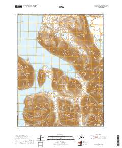
2020 Map of False Pass D-4 NW
USGS Topo · Published 2020About this map
Morzhovoi stands as the primary settlement on this stretch of the Alaska Peninsula, situated along the western shoreline. The landscape is defined by the high peaks of the Aleutian Range and the steep elevation of Traders Mtn, which drops sharply toward Traders Cove. Water dominates the western half of the survey, where the protected waters of Bechevin Bay and Hotsprings Bay meet the land. To the south, Protassof Bay opens toward the Pacific Ocean, illustrating the maritime character of this remote coastal region. This 2020 topographic data captures the isolation of these coastal outposts and the natural harbors that have historically served the area's residents.
Find a feature on this map
14 named features on this map. Tap any name to fly to it.
Don’t see what you’re looking for? This feature index may not catch every label — zoom into the map to look around manually.
Map Details
Editions of this 2020 False Pass D-4 NW Map
This is the sole edition of this map. No revisions or reprints were ever made.
Other maps of this area

1943 · Fort Randall
USGS Topo · 1:250,000

1949 · False Pass
USGS Topo · 1:250,000

1949 · Fort Randall
USGS Topo · 1:250,000

1950 · False Pass
USGS Topo · 1:250,000

1950 · Fort Randall
USGS Topo · 1:250,000
1995 · Cold Bay A-5
USGS Topo · 1:63,360
1995 · False Pass D-5
USGS Topo · 1:63,360
1995 · Cold Bay A-4
USGS Topo · 1:63,360
1995 · False Pass D-4
USGS Topo · 1:63,360
2020 · False Pass D-5 NE
USGS Topo · 1:25,000