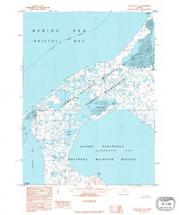
1995 Map of Cold Bay A-4
USGS Topo · Published 1995About this map
Izembek National Wildlife Refuge dominates this section of the Alaska Peninsula, showcasing a complex environment of lagoons and tidal flats where the Bering Sea meets the land. The topography is defined by the massive Big Lagoon and its smaller counterparts, Middle Lagoon and Little Lagoon, which are sheltered from Bristol Bay by the prominent sweep of Cape Glazenap. This coastal interface is a critical wildlife corridor, protected within the Izembek Wilderness.
Find a feature on this map
19 named features on this map. Tap any name to fly to it.
Don’t see what you’re looking for? This feature index may not catch every label — zoom into the map to look around manually.
Map Details
Editions of this 1995 Cold Bay A-4 Map
This is the sole edition of this map. No revisions or reprints were ever made.
Other maps of this area

1943 · Fort Randall
USGS Topo · 1:250,000
1944 · Cold Bay Sheet No. 20 of 25
USGS Topo · 1:25,000

1949 · False Pass
USGS Topo · 1:250,000

1949 · Fort Randall
USGS Topo · 1:250,000

1950 · False Pass
USGS Topo · 1:250,000

1950 · Fort Randall
USGS Topo · 1:250,000
1963 · False Pass D-3
USGS Topo · 1:63,360
1963 · Cold Bay B-3
USGS Topo · 1:63,360
1963 · Cold Bay B-4
USGS Topo · 1:63,360
1995 · Cold Bay A-5
USGS Topo · 1:63,360