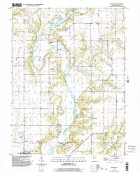
1998 Map of Fancher
USGS Topo · Published 2003About this map
The Kaskaskia River winds extensively through this portion of Shelby County, creating a riparian corridor defined by sharp meanders and floodplain lakes like Askins Lake. The landscape is notably marked by its historical infrastructure, most significantly the Thompson Mill Covered Bridge spanning the river in the southern reaches of the quadrangle. This structure, along with nearby crossings like Moore Bridge and Copeland Bridge, reflects the enduring importance of river transit in the local economy and social life.
Find a feature on this map
42 named features on this map. Tap any name to fly to it.
Don’t see what you’re looking for? This feature index may not catch every label — zoom into the map to look around manually.
Map Details
Editions of this 1998 Fancher Map
This is the sole edition of this map. No revisions or reprints were ever made.
Other maps of this area

1941 · St. Elmo
USGS Topo · 1:62,500

1942 · Shelbyville
USGS Topo · 1:62,500

1945 · St. Elmo
USGS Topo · 1:62,500

1946 · Shelbyville
USGS Topo · 1:62,500

1947 · Stewardson
USGS Topo · 1:62,500

1949 · Stewardson
USGS Topo · 1:62,500

1950 · Effingham
USGS Topo · 1:62,500

1951 · Effingham
USGS Topo · 1:62,500

1958 · Decatur
USGS Topo · 1:250,000

1961 · Decatur
USGS Topo · 1:250,000