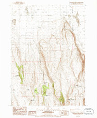
1986 Map of Fandango Canyon
USGS Topo · Published 1986About this map
Christmas Lake Valley defines the northern reaches of this mid-1980s landscape, where the flat basin floor meets the rising elevations of the high desert. The map captures a high-desert rangeland network essential for livestock and local travel, centered around Fandango Canyon and the prominent overlook at Viewpoint. Human activity is marked by isolated outposts like Viewpoint Ranch and Shull Well, alongside a system of reservoirs and waterholes including St Patrick Mtn Res No 4 and Toothless Waterhole.
Find a feature on this map
30 named features on this map. Tap any name to fly to it.
Don’t see what you’re looking for? This feature index may not catch every label — zoom into the map to look around manually.
Map Details
Editions of this 1986 Fandango Canyon Map
This is the sole edition of this map. No revisions or reprints were ever made.
Other maps of this area

1955 · Crescent
USGS Topo · 1:250,000

1957 · Crescent
USGS Topo · 1:250,000

1958 · Crescent
USGS Topo · 1:250,000

1970 · Crescent
USGS Topo · 1:250,000

1981 · Fossil Lake
USGS Topo · 1:24,000

1982 · Christmas Lake
USGS Topo · 1:24,000
1983 · Crack-in-the-Ground
USGS Topo · 1:24,000

1986 · St. Patrick Mtn.
USGS Topo · 1:24,000
1986 · Christmas Valley
USGS Topo · 1:24,000
1986 · Sheeplick Draw
USGS Topo · 1:24,000