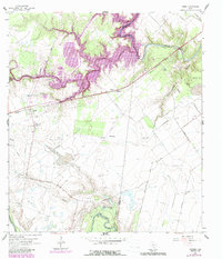
1962 Map of Fannin
USGS Topo · Published 1987About this map
Fannin and the surrounding coastal prairie south of Goliad reflect a landscape shaped by both historical remembrance and industrial development. The Fannin Battlefield Mon State Park stands as a prominent landmark on the west side of the sheet, commemorating the 1836 Battle of Coleto. The rural community of Cologne appears to the east, anchored by the Mallahau Ch and a nearby Cem, indicating a long-established local settlement pattern along the Southern Pacific rail line.
Find a feature on this map
35 named features on this map. Tap any name to fly to it.
Don’t see what you’re looking for? This feature index may not catch every label — zoom into the map to look around manually.
Map Details
Editions of this 1962 Fannin Map
2 editions found
Other maps of this area

1953 · Beeville
USGS Topo · 1:250,000

1956 · Beeville
USGS Topo · 1:250,000

1960 · Beeville
USGS Topo · 1:250,000

1962 · Live Oak Lake
USGS Topo · 1:24,000

1962 · Fannin
USGS Topo · 1:24,000

1962 · Lott Lake
USGS Topo · 1:24,000

1962 · McFaddin
USGS Topo · 1:24,000

1962 · Hensley Lake
USGS Topo · 1:24,000

1962 · Raisin
USGS Topo · 1:24,000
1963 · Ander
USGS Topo · 1:24,000