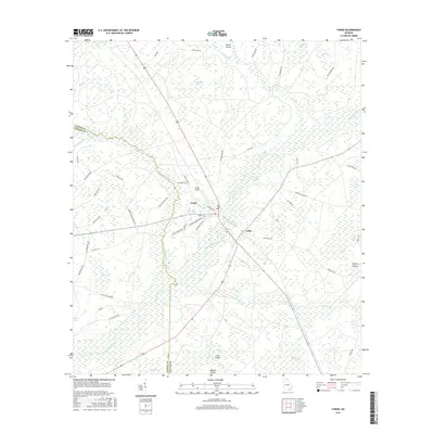
2017 Map of Fargo
USGS Topo · Published 2017About this map
The Suwannee River carves a path through this corner of Clinch and Echols Counties, anchoring a landscape defined by extensive wetlands and isolated islands. The settlement of Fargo serves as a central hub, where Fargo Airport and several local thoroughfares like Martin Luther King Dr and Alfred Griffis Rd converge. To the southeast lies Edith, situated near the confluence of the river and Cypress Cr. The terrain is characterized by a complex network of bays and swamps, including Horseshoe Swamp, Scoggin Bay, and Double Run Swamp, interspersed with elevated land masses such as Rozier Island and Wildcat Island. This 2017 survey reflects the enduring character of the Georgia lowlands, showing the continued relevance of rural tracks like Scab Town Rd and Woodpecker Rte in navigating the dense hydrologic systems of the Suwannoochee Cr basin.
Find a feature on this map
66 named features on this map. Tap any name to fly to it.
Don’t see what you’re looking for? This feature index may not catch every label — zoom into the map to look around manually.
Map Details
Editions of this 2017 Fargo Map
This is the sole edition of this map. No revisions or reprints were ever made.
Other maps of this area

1954 · Valdosta
USGS Topo · 1:250,000

1955 · Council
USGS Topo · 1:24,000

1955 · Fargo SW
USGS Topo · 1:24,000

1956 · Sargent
USGS Topo · 1:24,000

1958 · Valdosta
USGS Topo · 1:250,000

1959 · Valdosta
USGS Topo · 1:250,000

1966 · The Pocket
USGS Topo · 1:24,000

1967 · Strange Island
USGS Topo · 1:24,000

1967 · Colon
USGS Topo · 1:24,000

1967 · Sargent
USGS Topo · 1:24,000