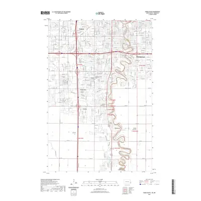
2020 Map of Fargo South
USGS Topo · Published 2020About this map
The Red River of the North winds in sharp, serpentine oxbows, defining the state boundary between North Dakota and Minnesota. On the western bank, the southern expansion of Fargo incorporates the small incorporated enclaves of Prairie Rose and Frontier, while Briarwood sits further south at the confluence where the Wild Rice River meets the main channel. The landscape is a study in modern suburban development and regional transit, dominated by the massive interchange of Interstate 29 and Interstate 94. For those tracing local heritage, the map is densely packed with significant burial grounds including Holy Cross Cem South, Sunset Memorial Gardens Cem, and Riverside Cem. Religious and community landmarks like the Gethsemane Cathedral and the Gethsemane Cathedral Garden Columbarium are clearly marked amidst the burgeoning residential street grid of the late 2010s.
Find a feature on this map
32 named features on this map. Tap any name to fly to it.
Don’t see what you’re looking for? This feature index may not catch every label — zoom into the map to look around manually.
Map Details
Editions of this 2020 Fargo South Map
This is the sole edition of this map. No revisions or reprints were ever made.
Other maps of this area

1895 · Fargo
USGS Topo · 1:125,000

1897 · Fargo
USGS Topo · 1:125,000

1953 · Fargo
USGS Topo · 1:250,000

1956 · Fargo
USGS Topo · 1:250,000

1959 · Fargo North
USGS Topo · 1:24,000

1959 · South West Fargo
USGS Topo · 1:24,000

1959 · Fargo South
USGS Topo · 1:24,000

1959 · Hickson
USGS Topo · 1:24,000

1959 · West Fargo
USGS Topo · 1:24,000
1959 · Norman
USGS Topo · 1:24,000