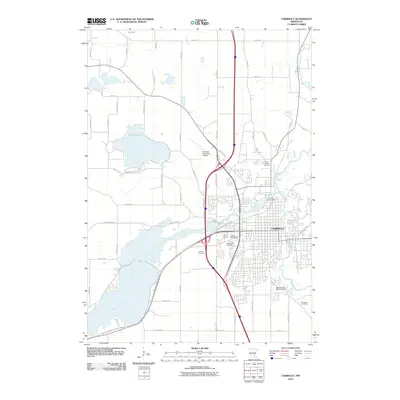
2010 Map of Faribault
USGS Topo · Published 2010About this map
The confluence of the Cannon River and the Straight River anchor the city of Faribault in this 2010 survey. The landscape is defined by its industrial and infrastructure hubs, notably the Kings Mill Dam and Cannon River Dam which historically powered the local economy. In the residential and outlying areas, several significant burial grounds including Saint Lawrence Cemetery, Calvary Cemetery, and Maple Lawn Cemetery offer clear points of interest for genealogists and local historians. To the west, the large expanse of Roberds Lake and the smaller Twin Lakes provide a contrast to the structured grid of the city, while the Faribault Municipal Airport and a network of arterial roads like Cedar Lake Blvd and Bagley Ave illustrate the modern transportation layout of Rice County.
Find a feature on this map
54 named features on this map. Tap any name to fly to it.
Don’t see what you’re looking for? This feature index may not catch every label — zoom into the map to look around manually.
Map Details
Editions of this 2010 Faribault Map
This is the sole edition of this map. No revisions or reprints were ever made.
Other maps of this area

1953 · Saint Paul
USGS Topo · 1:250,000

1959 · Saint Paul
USGS Topo · 1:250,000

1960 · Faribault
USGS Topo · 1:24,000

1960 · Northfield
USGS Topo · 1:24,000

1960 · Cannon City
USGS Topo · 1:24,000

1960 · Shieldsville
USGS Topo · 1:24,000

1960 · Lonsdale
USGS Topo · 1:24,000

1960 · Little Chicago
USGS Topo · 1:24,000

1962 · Medford East
USGS Topo · 1:24,000

1962 · Morristown
USGS Topo · 1:24,000