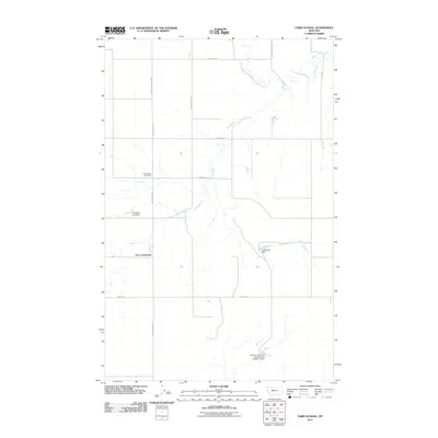
2011 Map of Faris School
USGS Topo · Published 2011About this map
East Community serves as a focal point for this agrarian landscape in Pondera County, where a network of section-line roads like Golden West Rd and Brady Rd E defines the rural organization. The map documents the educational history of the region by marking the site of Faris School (Historical), situated along its namesake Faris School Rd. Water management is a primary feature of the local topography, evidenced by several specialized structures including Ponderosa Pine Dam and the uniquely named Just Barely Dam. Further south, the McLean and Sons Incorporated Number 1 Dam indicates the presence of established family-run operations. The terrain is further etched by natural drainage features such as Dead Indian Coulee Rd, which follows the contours of the local coulees and breaks.
Find a feature on this map
15 named features on this map. Tap any name to fly to it.
Don’t see what you’re looking for? This feature index may not catch every label — zoom into the map to look around manually.
Map Details
Editions of this 2011 Faris School Map
This is the sole edition of this map. No revisions or reprints were ever made.
Other maps of this area

1886 · Great Falls
USGS Topo · 1:250,000

1920 · Conrad
USGS Topo · 1:125,000

1949 · Timber Coulee
USGS Topo · 1:62,500

1950 · Timber Coulee
USGS Topo · 1:62,500

1950 · Dutton
USGS Topo · 1:62,500

1954 · Great Falls
USGS Topo · 1:250,000

1954 · Shelby
USGS Topo · 1:250,000

1957 · Great Falls
USGS Topo · 1:250,000

1958 · Shelby
USGS Topo · 1:250,000
1967 · Fowler Coulee SE
USGS Topo · 1:24,000