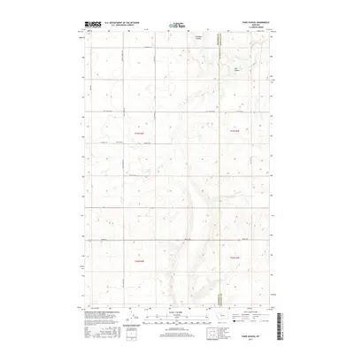
2017 Map of Faris School
USGS Topo · Published 2017About this map
Faris School stands as a focal point in this portion of North Central Montana, situated within a vast grid of section lines and gravel roads that define the rural landscape. The area is characterized by the deep incisions of Pondera Coulee and Flat Coulee, which disrupt the otherwise orderly township and range divisions. The network of local roads carries the names of early resident families, such as Stordahl Rd, Hog Johnson Rd, and Ferris School N Rd. This 2017 survey by the U.S. Geological Survey captures the modern topography of a region straddling the border between Pondera and Chouteau counties, illustrating how natural drainage patterns and the historic public land survey system dictate the placement of local infrastructure and dwellings.
Find a feature on this map
21 named features on this map. Tap any name to fly to it.
Don’t see what you’re looking for? This feature index may not catch every label — zoom into the map to look around manually.
Map Details
Editions of this 2017 Faris School Map
This is the sole edition of this map. No revisions or reprints were ever made.
Other maps of this area

1886 · Great Falls
USGS Topo · 1:250,000

1920 · Conrad
USGS Topo · 1:125,000

1949 · Timber Coulee
USGS Topo · 1:62,500

1950 · Timber Coulee
USGS Topo · 1:62,500

1950 · Dutton
USGS Topo · 1:62,500

1954 · Great Falls
USGS Topo · 1:250,000

1954 · Shelby
USGS Topo · 1:250,000

1957 · Great Falls
USGS Topo · 1:250,000

1958 · Shelby
USGS Topo · 1:250,000
1967 · Fowler Coulee SE
USGS Topo · 1:24,000