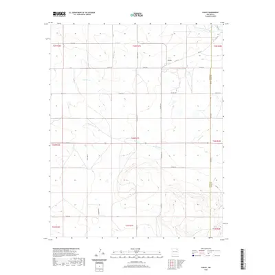
2020 Map of Farley
USGS Topo · Published 2020About this map
Farley stands as the primary settlement in this high plains landscape on the eastern edge of Colfax County, where the terrain is defined by wide drainages and a network of named section roads. Water is a scarce and vital resource, represented by the winding Sand Arroyo, Wilson Arroyo, and the isolated Lanier Lake. The map illustrates a strictly organized grid of land management and transportation, featuring routes like Rock Lake Rd and Hackamore Rd that connect remote ranching interests. The boundary between Colfax and Union counties runs along the eastern edge of the quadrangle, primarily following Rose Rd and Co RD c064. This 2020 survey captures the enduring rural character of northeastern New Mexico, where large-scale land tracts and seasonal watercourses like Holkeo Cr shape the movement of people and livestock.
Find a feature on this map
38 named features on this map. Tap any name to fly to it.
Don’t see what you’re looking for? This feature index may not catch every label — zoom into the map to look around manually.
Map Details
Editions of this 2020 Farley Map
This is the sole edition of this map. No revisions or reprints were ever made.
Other maps of this area

1954 · Raton
USGS Topo · 1:250,000

1954 · Dalhart
USGS Topo · 1:250,000

1958 · Raton
USGS Topo · 1:250,000

1958 · Dalhart
USGS Topo · 1:250,000

1962 · Dalhart
USGS Topo · 1:250,000

1973 · Gladstone NW
USGS Topo · 1:24,000

1974 · Point Of Rocks Mesa
USGS Topo · 1:24,000

1974 · Farley
USGS Topo · 1:24,000
1974 · Lawrence Arroyo
USGS Topo · 1:24,000

1974 · Spear Hills
USGS Topo · 1:24,000