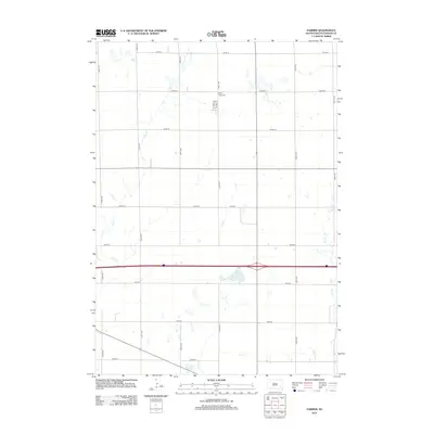
2012 Map of Farmer
USGS Topo · Published 2012About this map
Saint Peter Cem serves as a central landmark in this portion of Hanson County, situated north of the Interstate 90 corridor. The landscape is defined by the regular grid of township roads, including 426th Ave and 252nd St, which organize the agricultural terrain. This survey reflects the modern rural infrastructure of South Dakota in the early 2010s, where small water bodies like Welker Lake and intermittent drainage systems such as Pierre Cr and Bloom Cr dictate the local geography. The map captures a quiet section of the plains where the legacy of early settlement is preserved in the names of family-related sites and cemeteries, while the broader drainage patterns of Wolf Cr and Plum Cr influence the southeast corner of the quadrangle.
Find a feature on this map
22 named features on this map. Tap any name to fly to it.
Don’t see what you’re looking for? This feature index may not catch every label — zoom into the map to look around manually.
Map Details
Editions of this 2012 Farmer Map
This is the sole edition of this map. No revisions or reprints were ever made.
Other maps of this area

1899 · Alexandria
USGS Topo · 1:125,000

1955 · Sioux Falls
USGS Topo · 1:250,000

1957 · Alexandria
USGS Topo · 1:24,000

1957 · Rockport Colony
USGS Topo · 1:24,000

1958 · Sioux Falls
USGS Topo · 1:250,000

1973 · Spencer SW
USGS Topo · 1:24,000

1973 · Ness Chain Lakes
USGS Topo · 1:24,000

1973 · Farmer
USGS Topo · 1:24,000
1973 · Bridgewater West
USGS Topo · 1:24,000

1973 · Canova SE
USGS Topo · 1:24,000