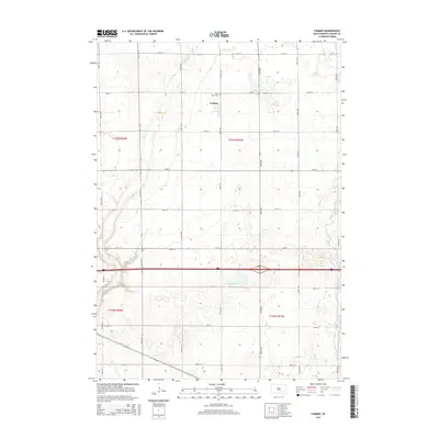
2015 Map of Farmer
USGS Topo · Published 2015About this map
Farmer stands as the central settlement in this Hanson County landscape, surrounded by a precise grid of rural roads and agricultural sections. This 2015 U.S. Geological Survey representation captures the area's drainage patterns, defined by the winding paths of Pierre Cr and Bloom Cr as they cut through the prairie. Near the town site, Saint Peter Cem provides a specific point of interest for genealogists and local historians, serving as a primary landmark for the community. To the south, the terrain is marked by Welker Lake and the intersection of various creeks like Plum Cr and Wolf Cr. The map illustrates a modern rural infrastructure where established section lines such as 251st St and 427th Ave dictate the movement across the South Dakota plains, reflecting the enduring township-and-range layout of the region.
Find a feature on this map
27 named features on this map. Tap any name to fly to it.
Don’t see what you’re looking for? This feature index may not catch every label — zoom into the map to look around manually.
Map Details
Editions of this 2015 Farmer Map
This is the sole edition of this map. No revisions or reprints were ever made.
Other maps of this area

1899 · Alexandria
USGS Topo · 1:125,000

1955 · Sioux Falls
USGS Topo · 1:250,000

1957 · Alexandria
USGS Topo · 1:24,000

1957 · Rockport Colony
USGS Topo · 1:24,000

1958 · Sioux Falls
USGS Topo · 1:250,000

1973 · Spencer SW
USGS Topo · 1:24,000

1973 · Ness Chain Lakes
USGS Topo · 1:24,000

1973 · Farmer
USGS Topo · 1:24,000
1973 · Bridgewater West
USGS Topo · 1:24,000

1973 · Canova SE
USGS Topo · 1:24,000