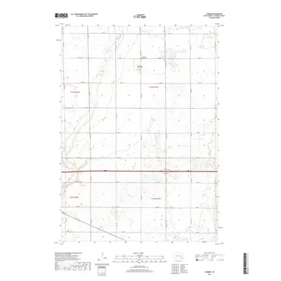
2017 Map of Farmer
USGS Topo · Published 2017About this map
Farmer serves as the central hub of this agricultural landscape in Hanson County, situated amidst a dense grid of section roads and rolling drainages. The settlement is anchored by local infrastructure along Joe St, while the Saint Peters Catholic Cem to the north stands as a significant landmark for genealogical research. The area's hydrology is defined by a network of seasonal and permanent watercourses, including the westward-flowing Pierre Cr and the southern reaches of Bloom Cr and Plum Cr. These streams, alongside Welker Lake, dictate the placement of farms and transit corridors across the prairie. The map provides a clear view of the rural township structure, showing how Interstate 90 and various secondary routes like 252nd St and 427th Ave overlay the traditional land divisions of the early twenty-first century.
Find a feature on this map
29 named features on this map. Tap any name to fly to it.
Don’t see what you’re looking for? This feature index may not catch every label — zoom into the map to look around manually.
Map Details
Editions of this 2017 Farmer Map
This is the sole edition of this map. No revisions or reprints were ever made.
Other maps of this area

1899 · Alexandria
USGS Topo · 1:125,000

1955 · Sioux Falls
USGS Topo · 1:250,000

1957 · Alexandria
USGS Topo · 1:24,000

1957 · Rockport Colony
USGS Topo · 1:24,000

1958 · Sioux Falls
USGS Topo · 1:250,000

1973 · Spencer SW
USGS Topo · 1:24,000

1973 · Ness Chain Lakes
USGS Topo · 1:24,000

1973 · Farmer
USGS Topo · 1:24,000
1973 · Bridgewater West
USGS Topo · 1:24,000

1973 · Canova SE
USGS Topo · 1:24,000