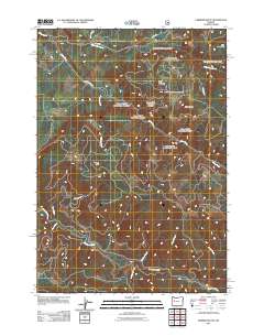
2011 Map of Farmers Butte
USGS Topo · Published 2011About this map
Farmers Butte and the surrounding high country of Lane County are defined by a complex network of timber access and drainage systems. The Calapooia River winds through the southern portion of the quadrangle, fed by a series of steep tributaries including McKinley Creek, Washout Creek, and Barrell Creek. This landscape is primarily industrial and natural, with Harris Rd and Wiley Mountain Rd providing the only primary terrestrial links through the elevations of Buck Mountain and Green Butte.
Find a feature on this map
18 named features on this map. Tap any name to fly to it.
Don’t see what you’re looking for? This feature index may not catch every label — zoom into the map to look around manually.
Map Details
Editions of this 2011 Farmers Butte Map
This is the sole edition of this map. No revisions or reprints were ever made.
Other maps of this area

1934 · Mc Kenzie Bridge
USGS Topo · 1:96,000

1940 · Mc Kenzie Bridge
USGS Topo · 1:125,000

1951 · Sweet Home
USGS Topo · 1:62,500

1951 · Leaburg
USGS Topo · 1:62,500

1953 · Salem
USGS Topo · 1:250,000

1954 · Salem
USGS Topo · 1:250,000

1955 · Blue River
USGS Topo · 1:62,500

1955 · Cascadia
USGS Topo · 1:62,500

1960 · Salem
USGS Topo · 1:250,000

1962 · Salem
USGS Topo · 1:250,000