
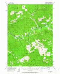
1955 Map of Blue River
USGS Topo · Published 1958About this map
Mining operations and timber management dominate this mid-century landscape in the Willamette National Forest. Several hard-rock mining sites appear in the northern reaches, including the Lucky Boy Mine, Cinderella Mine, and North Star Mine, along with the solitary Renfrew Grave near Renfrew Spring. The valley floor follows the course of the McKenzie Highway and the McKenzie River, where small communities like Blue River, Finn Rock, and Nimrod provide commercial hubs for the surrounding woods. Local infrastructure is marked by the McKenzie HS, multiple millponds, and the Holman Guard Sta. The network of waters including the South Fork McKenzie River and Quartz Creek suggests a reliance on river systems for both the timber industry at Lumber Camp and recreation at Rennie Landing.
Find a feature on this map
81 named features on this map. Tap any name to fly to it.
Don’t see what you’re looking for? This feature index may not catch every label — zoom into the map to look around manually.
Map Details
Editions of this 1955 Blue River Map
2 editions found
Other maps of this area

1925 · Waldo Lake
USGS Topo · 1:125,000

1934 · Mc Kenzie Bridge
USGS Topo · 1:96,000

1935 · Lowell
USGS Topo · 1:96,000

1940 · Mc Kenzie Bridge
USGS Topo · 1:125,000

1942 · Lowell
USGS Topo · 1:125,000

1951 · Sweet Home
USGS Topo · 1:62,500

1951 · Leaburg
USGS Topo · 1:62,500

1953 · Salem
USGS Topo · 1:250,000

1954 · Salem
USGS Topo · 1:250,000

1955 · Hardesty Mtn
USGS Topo · 1:62,500