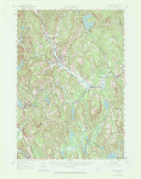
1956 Map of Farmington
USGS Topo · Published 1972About this map
Sandy River winds through the heart of this mid-century landscape, anchoring the regional centers of Farmington and West Farmington. The era’s transportation network is defined by the Maine Central railroad, which services the industrial and residential pockets of Wilton and Dryden. This map reveals a transition between concentrated village life and the outlying rural economy, where local landmarks like Bullen Mills and Weeks Mills hint at a history tied to the area's numerous watercourses, including Wilson Stream and Barker Stream.
Find a feature on this map
85 named features on this map. Tap any name to fly to it.
Don’t see what you’re looking for? This feature index may not catch every label — zoom into the map to look around manually.
Map Details
Editions of this 1956 Farmington Map
3 editions found

Other maps of this area

1892 · Augusta
USGS Topo · 1:62,500

1894 · Norridgewock
USGS Topo · 1:62,500

1898 · Norridgewock
USGS Topo · 1:62,500

1904 · Anson
USGS Topo · 1:62,500

1910 · Livermore
USGS Topo · 1:62,500

1911 · Buckfield
USGS Topo · 1:62,500

1912 · Livermore
USGS Topo · 1:62,500

1913 · Buckfield
USGS Topo · 1:62,500

1924 · Farmington
USGS Topo · 1:62,500

1926 · Dixfield
USGS Topo · 1:62,500