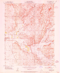
1953 Map of Farmington
USGS Topo · Published 1954About this map
Farmington serves as the primary hub of this landscape at the intersection of the Southern Pacific railroad and early thoroughfares like Copperopolis Road. The map reveals a transition from traditional agricultural settlements to modern infrastructure, centered around the massive Farmington Dam and its associated Flood Control Basin. This massive hydraulic project altered the drainage of Littlejohns Creek and Duck Creek, reflecting the mid-century effort to manage the seasonal waters of the Central Valley.
Find a feature on this map
26 named features on this map. Tap any name to fly to it.
Don’t see what you’re looking for? This feature index may not catch every label — zoom into the map to look around manually.
Map Details
Editions of this 1953 Farmington Map
This is the sole edition of this map. No revisions or reprints were ever made.
Other maps of this area

1889 · Jackson
USGS Topo · 1:125,000

1892 · Jackson
USGS Topo · 1:125,000

1894 · Lodi
USGS Topo · 1:125,000

1897 · Jackson
USGS Topo · 1:125,000

1902 · Jackson
USGS Topo · 1:125,000

1908 · Linden
USGS Topo · 1:31,680

1914 · Avena
USGS Topo · 1:31,680

1915 · Oakdale
USGS Topo · 1:31,680

1915 · Trigo
USGS Topo · 1:31,680

1915 · Peters
USGS Topo · 1:31,680