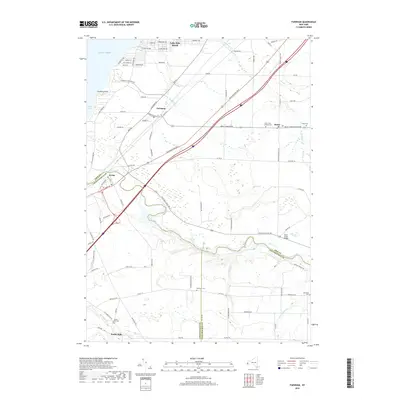
2019 Map of Farnham
USGS Topo · Published 2019About this map
Cattaraugus Creek carves a deep valley through the southern portion of this region, serving as the natural boundary between Erie, Chautauqua, and Cattaraugus Counties. The landscape transitions from the sandy shores of Lake Erie at Lotus Bay and the wooded recreation area of Evangola State Park to the fertile agricultural plains surrounding Brant. This modern survey documents the transportation corridors that define the area, including the Erie Rd railroad and the Southwestern Blvd expressway. Smaller hamlets like Irving, Farnham, and Smith Mills are detailed alongside their local history markers, such as the Smiths Mill Cem and Rathburn Cem. Notable water bodies like Delaware Cr and Muddy Cr drain northwest toward the lake, shaping the development of lakeside communities like Lake Erie Beach.
Find a feature on this map
93 named features on this map. Tap any name to fly to it.
Don’t see what you’re looking for? This feature index may not catch every label — zoom into the map to look around manually.
Map Details
Editions of this 2019 Farnham Map
This is the sole edition of this map. No revisions or reprints were ever made.
Other maps of this area

1899 · Silver Creek
USGS Topo · 1:62,500

1900 · Cherry Creek
USGS Topo · 1:62,500

1905 · Eden
USGS Topo · 1:62,500

1907 · Eden
USGS Topo · 1:62,500

1923 · Cattaraugus
USGS Topo · 1:62,500

1938 · Cattaraugus
USGS Topo · 1:62,500

1941 · Cattaraugus
USGS Topo · 1:62,500

1941 · Cherry Creek
USGS Topo · 1:62,500

1943 · Silver Creek
USGS Topo · 1:24,000

1944 · Eden
USGS Topo · 1:62,500