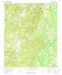
1978 Map of Farrington
USGS Topo · Published 1978About this map
B. Everett Jordan Lake dominates the eastern landscape of this North Carolina survey, representing a significant transformation of the Haw River valley. Blue-hatched areas on the map indicate land intended to be submerged by the reservoir, illustrating the impact on the local geography and the shift toward modern water management in the late 1970s. The terrain is marked by prominent peaks such as Edwards Mountain and Boothe Hill, interspersed with a network of established community landmarks. Genealogists and local historians can locate several rural religious centers, including Mt Carmel Ch and Forest Grove Chapel, alongside family-named burial grounds like Manns Chapel Cem and Riggsbee Cem. The map captures the quiet transition of settlements like Farrington and Bells as they adapted to the rising waters of the newly formed lake.
Find a feature on this map
52 named features on this map. Tap any name to fly to it.
Don’t see what you’re looking for? This feature index may not catch every label — zoom into the map to look around manually.
Map Details
Editions of this 1978 Farrington Map
2 editions found
Other maps of this area

1943 · Durham South
USGS Topo · 1:62,500

1946 · Chapel Hill
USGS Topo · 1:24,000

1947 · Chapel Hill
USGS Topo · 1:31,680

1951 · Farrington
USGS Topo · 1:24,000

1951 · Durham South
USGS Topo · 1:62,500

1953 · Raleigh
USGS Topo · 1:250,000

1954 · Raleigh
USGS Topo · 1:250,000

1968 · White Cross
USGS Topo · 1:24,000

1968 · Bynum
USGS Topo · 1:24,000

1969 · New Hope Dam
USGS Topo · 1:24,000