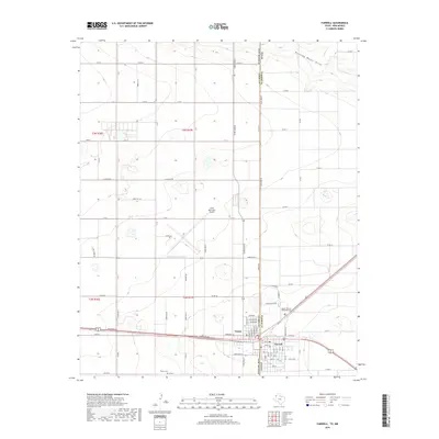
2019 Map of Farwell
USGS Topo · Published 2019About this map
Texico and Farwell stand as twin communities divided only by the straight line of the New Mexico and Texas border. This high plains landscape is defined by the grid of county roads and the drainage of Running Water Draw in the northeast. The presence of the Clovis Municipal Airport and the convergence of major thoroughfares like Wheeler Ave and Hereford Ave indicate the area's importance as a regional transportation and agricultural hub. Local history is anchored by sites such as the Texico Cem and Sunset Terrace Memorial Cem, while the residential expansion is evident in the street networks of both towns, including named ways like Eunice Ave and Country Club Dr. The terrain is characterized by numerous small depressions and basins typical of the Llano Estacado, contrasting with the engineered precision of the state boundary.
Find a feature on this map
44 named features on this map. Tap any name to fly to it.
Don’t see what you’re looking for? This feature index may not catch every label — zoom into the map to look around manually.
Map Details
Editions of this 2019 Farwell Map
This is the sole edition of this map. No revisions or reprints were ever made.
Other maps of this area

1954 · Clovis
USGS Topo · 1:250,000

1957 · Clovis
USGS Topo · 1:62,500

1957 · Pleasant Hill
USGS Topo · 1:62,500

1958 · Clovis
USGS Topo · 1:250,000

1963 · Lariat
USGS Topo · 1:24,000

1963 · Oklahoma Lane
USGS Topo · 1:24,000

1965 · Bovina
USGS Topo · 1:24,000

1985 · Midway
USGS Topo · 1:24,000

1985 · Pleasure Lake
USGS Topo · 1:24,000

1985 · Muleshoe
USGS Topo · 1:100,000