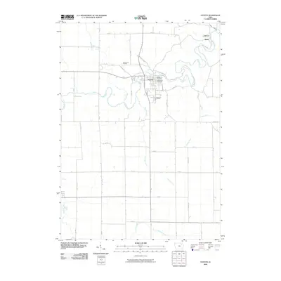
2010 Map of Fayette
USGS Topo · Published 2010About this map
The Volga River and its multiple tributaries, including Little Volga River, Grannis Creek, and Alexander Creek, define the topography around the city of Fayette. This university town is centered on the campus of Upper Iowa University, with the Fayette Post Office and nearby Grandview Cemetery serving as local landmarks. The landscape is a structured grid of rural roads like Jade Rd and Hill Rd, reflecting the agricultural character of Fayette County. North of the city, the small settlement of Albany sits near the Volga River Campground, where the river makes a series of sharp bends. Genealogists may find value in the clear locations of Saint Francis Cemetery and other burial grounds, while the inclusion of older routes like Old Hwy 150 N provides a look at the area's evolving transportation network.
Find a feature on this map
28 named features on this map. Tap any name to fly to it.
Don’t see what you’re looking for? This feature index may not catch every label — zoom into the map to look around manually.
Map Details
Editions of this 2010 Fayette Map
This is the sole edition of this map. No revisions or reprints were ever made.
Other maps of this area

1901 · Oelwein
USGS Topo · 1:125,000

1959 · Dubuque
USGS Topo · 1:250,000

1961 · Dubuque
USGS Topo · 1:250,000

1962 · Dubuque
USGS Topo · 1:250,000

1965 · Elgin
USGS Topo · 1:24,000

1965 · Wadena
USGS Topo · 1:24,000

1965 · Arlington
USGS Topo · 1:24,000

1976 · Dubuque
USGS Topo · 1:250,000
1981 · Stanley
USGS Topo · 1:24,000
1981 · Maynard
USGS Topo · 1:24,000