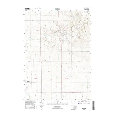
2015 Map of Fayette
USGS Topo · Published 2015About this map
Upper Iowa University anchors the heart of Fayette, where the town sits at a sharp bend in the Volga River. This northeastern Iowa landscape is defined by the river's winding path through the limestone bluffs and the fertile agricultural land of Township 93 North, Range 8 West. The settlement of Albany appears to the northeast, near the topographic feature known as Frog Hollow, while the village of Maynard occupies the southwestern corner of the quadrangle. Local heritage is preserved in several burial grounds, including Grandview Cemetery and the more remote Center Grove Cemetery. The map illustrates a well-developed road network connecting these rural communities, such as Old Highway 150 North and Wadena Road, tracing the transition from the river valley to the upland prairies drained by Alexander Creek and the Little Volga River.
Find a feature on this map
57 named features on this map. Tap any name to fly to it.
Don’t see what you’re looking for? This feature index may not catch every label — zoom into the map to look around manually.
Map Details
Editions of this 2015 Fayette Map
This is the sole edition of this map. No revisions or reprints were ever made.
Other maps of this area

1901 · Oelwein
USGS Topo · 1:125,000

1959 · Dubuque
USGS Topo · 1:250,000

1961 · Dubuque
USGS Topo · 1:250,000

1962 · Dubuque
USGS Topo · 1:250,000

1965 · Elgin
USGS Topo · 1:24,000

1965 · Wadena
USGS Topo · 1:24,000

1965 · Arlington
USGS Topo · 1:24,000

1976 · Dubuque
USGS Topo · 1:250,000
1981 · Stanley
USGS Topo · 1:24,000
1981 · Maynard
USGS Topo · 1:24,000