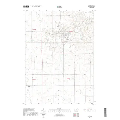
2018 Map of Fayette
USGS Topo · Published 2018About this map
The Volga River winds through this section of Fayette County, anchoring the town of Fayette and the nearby settlement of Albany. The terrain is defined by its watercourses, including Coulee Cr and the sharp relief of Frog Hollow in the northeast. This 2018 survey documents the intricate grid of the town center, featuring streets such as W Clark St, Main St, and E State St. Genealogists will find the locations of Grandview Cem and Saint Francis Cem essential for tracing local family history. To the southwest, the town of Maynard sits near the banks of the Little Volga River, marking a distinct node in the region's agricultural landscape. The map provides a detailed view of rural road networks, like Lantern Rd and Wadena Rd, connecting these river-valley communities.
Find a feature on this map
51 named features on this map. Tap any name to fly to it.
Don’t see what you’re looking for? This feature index may not catch every label — zoom into the map to look around manually.
Map Details
Editions of this 2018 Fayette Map
This is the sole edition of this map. No revisions or reprints were ever made.
Other maps of this area

1901 · Oelwein
USGS Topo · 1:125,000

1959 · Dubuque
USGS Topo · 1:250,000

1961 · Dubuque
USGS Topo · 1:250,000

1962 · Dubuque
USGS Topo · 1:250,000

1965 · Elgin
USGS Topo · 1:24,000

1965 · Wadena
USGS Topo · 1:24,000

1965 · Arlington
USGS Topo · 1:24,000

1976 · Dubuque
USGS Topo · 1:250,000
1981 · Stanley
USGS Topo · 1:24,000
1981 · Maynard
USGS Topo · 1:24,000