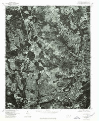
1976 Map of Fayetteville
USGS Topo · Published 1978About this map
Fayetteville is seen here at a period of significant suburban development during the mid-1970s. This orthophotograph, rectified from aerial imagery taken in early 1976, provides a rare visual of the land use patterns and densifying residential grids in Cumberland County. The map details the expansion of Bonnie Doone to the northwest and the established neighborhoods of Lakedale to the south. Unlike traditional line-drawn topographic maps, this imagery-based survey shows the actual density of forest cover remaining between the burgeoning housing tracts and commercial corridors, offering a literal view of the North Carolina landscape as it existed before decades of further southern urban sprawl changed the outskirts of the city.
Find a feature on this map
3 named features on this map. Tap any name to fly to it.
Don’t see what you’re looking for? This feature index may not catch every label — zoom into the map to look around manually.
Map Details
Editions of this 1976 Fayetteville Map
This is the sole edition of this map. No revisions or reprints were ever made.
Other maps of this area

1948 · Fayetteville
USGS Topo · 1:62,500

1948 · Clifdale
USGS Topo · 1:62,500

1948 · Slocomb
USGS Topo · 1:24,000

1948 · Clifdale
USGS Topo · 1:24,000

1949 · Vander
USGS Topo · 1:24,000

1950 · Clifdale
USGS Topo · 1:24,000

1950 · Fayetteville
USGS Topo · 1:24,000

1950 · Manchester
USGS Topo · 1:24,000

1950 · Slocomb
USGS Topo · 1:24,000

1951 · Clifdale
USGS Topo · 1:62,500