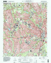
1997 Map of Fayetteville
USGS Topo · Published 2000About this map
Fayetteville serves as the dense urban heart of this late-twentieth-century landscape, characterized by its complex intersection of civilian life and military presence. The sprawling Fort Bragg Military Reservation dominates the northwest, while the city's growth is traced through neighborhoods like Haymount and Lakedale. Educational and civic pillars are central to the community, notably Fayetteville State University and the Veterans Hospital.
Find a feature on this map
63 named features on this map. Tap any name to fly to it.
Don’t see what you’re looking for? This feature index may not catch every label — zoom into the map to look around manually.
Map Details
Editions of this 1997 Fayetteville Map
This is the sole edition of this map. No revisions or reprints were ever made.
Other maps of this area

1948 · Fayetteville
USGS Topo · 1:62,500

1948 · Clifdale
USGS Topo · 1:62,500

1948 · Slocomb
USGS Topo · 1:24,000

1948 · Clifdale
USGS Topo · 1:24,000

1949 · Vander
USGS Topo · 1:24,000

1950 · Clifdale
USGS Topo · 1:24,000

1950 · Fayetteville
USGS Topo · 1:24,000

1950 · Manchester
USGS Topo · 1:24,000

1950 · Slocomb
USGS Topo · 1:24,000

1951 · Clifdale
USGS Topo · 1:62,500