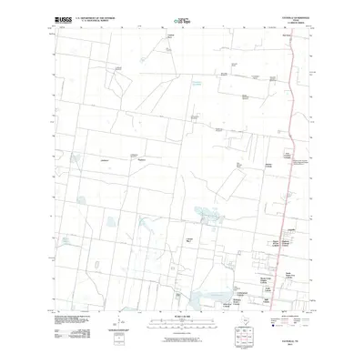
2010 Map of Faysville
USGS Topo · Published 2010About this map
Laguna Seca and the surrounding ranchlands north of McAllen are defined by a network of traditional Hispanic family ranchos and modern residential developments. This South Texas landscape is dotted with functional landmarks essential for arid-climate livestock management, including the La Morita Windmill, San Jose Windmill, and Segrado Carazon Windmill. The agricultural heritage of the region is evident in named holdings like Guadalupe Ranch and Serraldo Ranch, while more recent urbanization is reflected in the numerous colonias such as Alsonia Colonia and Puerta del Sol Colonia concentrated along the main transit corridors.
Find a feature on this map
56 named features on this map. Tap any name to fly to it.
Don’t see what you’re looking for? This feature index may not catch every label — zoom into the map to look around manually.
Map Details
Editions of this 2010 Faysville Map
This is the sole edition of this map. No revisions or reprints were ever made.
Other maps of this area

1939 · Linn
USGS Topo · 1:62,500

1939 · La Reforma
USGS Topo · 1:62,500

1940 · Monte Christo
USGS Topo · 1:62,500

1949 · Mc Allen
USGS Topo · 1:250,000

1954 · McAllen
USGS Topo · 1:250,000

1957 · Mc Allen
USGS Topo · 1:250,000

1962 · McAllen
USGS Topo · 1:250,000

1963 · Monte Christo
USGS Topo · 1:24,000
1963 · Hargill
USGS Topo · 1:24,000

1963 · Edinburg
USGS Topo · 1:24,000