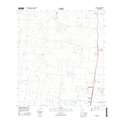
2016 Map of Faysville
USGS Topo · Published 2016About this map
Laguna Seca and the nearby Vela Cem anchor the northern landscape of this South Texas survey, where the brush and pasture lands of the Rio Grande Valley meet organized development. The map details the transition from rural ranching features like Jackson Pasture and Guajolotes Enramada to the growing residential footprints of Edinburg and Faysville in the south. Aviation infrastructure is a prominent modern landmark with the South Texas International Airport at Edinburg situated near the intersection of major transit corridors. Significant water features including Lake Edinburg and Sapo Lake dot the terrain, while the residential developments of Pralle Colonia and BJB Colonia illustrate the local housing patterns of Hidalgo County. A dense network of roads, from FM 490 to family-named routes like Hinojosa Rd, reveals the connectivity between isolated settlements like Linn and Red Gate.
Find a feature on this map
61 named features on this map. Tap any name to fly to it.
Don’t see what you’re looking for? This feature index may not catch every label — zoom into the map to look around manually.
Map Details
Editions of this 2016 Faysville Map
This is the sole edition of this map. No revisions or reprints were ever made.
Other maps of this area

1939 · Linn
USGS Topo · 1:62,500

1939 · La Reforma
USGS Topo · 1:62,500

1940 · Monte Christo
USGS Topo · 1:62,500

1949 · Mc Allen
USGS Topo · 1:250,000

1954 · McAllen
USGS Topo · 1:250,000

1957 · Mc Allen
USGS Topo · 1:250,000

1962 · McAllen
USGS Topo · 1:250,000

1963 · Monte Christo
USGS Topo · 1:24,000
1963 · Hargill
USGS Topo · 1:24,000

1963 · Edinburg
USGS Topo · 1:24,000