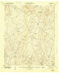
1946 Map of Felker
USGS Topo · Published 1947About this map
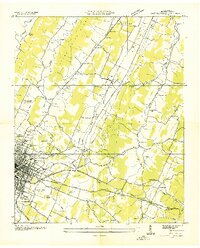
Coahulla Creek and its many branches wind through this section of the Tennessee Valley, defining a landscape of small agricultural settlements and rural social hubs in the mid-1940s. The area is anchored by community nodes like Pumpkin Center, Sugar Grove, and the small siding at Felker, each serving as a focal point for the surrounding farmsteads. The high density of spiritual and educational landmarks, such as Kinser Tabernacle, Good Will Ch, and Wooten Sch, reflects a decentralized but deeply rooted social structure.
Find a feature on this map
48 named features on this map. Tap any name to fly to it.
Don’t see what you’re looking for? This feature index may not catch every label — zoom into the map to look around manually.
Map Details
Editions of this 1946 Felker Map
2 editions found
Other maps of this area

1886 · Dalton
USGS Topo · 1:125,000

1886 · Cleveland
USGS Topo · 1:125,000

1892 · Cleveland
USGS Topo · 1:125,000

1892 · Dalton
USGS Topo · 1:125,000

1895 · Cleveland
USGS Topo · 1:125,000

1897 · Dalton
USGS Topo · 1:125,000

1901 · Cleveland
USGS Topo · 1:125,000
1911 · Cohutta Mtn
USGS Topo · 1:62,500
1913 · Cohutta Mtn.
USGS Topo · 1:62,500
1935 · East Cleveland
USGS Topo · 1:24,000