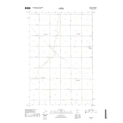
2019 Map of Felton
USGS Topo · Published 2019About this map
The town of Felton serves as the central hub of this agricultural landscape in Clay County, Minnesota. The terrain is defined by a precise section-line grid of rural roads, including Co Hwy 38 and Co Hwy 19, which facilitate the movement of goods across the fertile Red River Valley. The intermittent course of Felton Cr winds through the northwestern corner of the map, providing a rare natural break in the otherwise geometric layout of fields and farmsteads. Genealogical researchers will find significant interest in the peripheral burial grounds that anchor the local community, specifically Felton Cem located just south of the main township and Scandia Cem situated further south along Co Rd 28. This 2019 survey documents the enduring spatial organization of a classic Midwestern farming district, where large-scale townships like t142n r46w maintain their historical boundaries.
Find a feature on this map
30 named features on this map. Tap any name to fly to it.
Don’t see what you’re looking for? This feature index may not catch every label — zoom into the map to look around manually.
Map Details
Editions of this 2019 Felton Map
This is the sole edition of this map. No revisions or reprints were ever made.
Other maps of this area

1895 · Fargo
USGS Topo · 1:125,000

1897 · Fargo
USGS Topo · 1:125,000

1918 · Ulen
USGS Topo · 1:62,500

1919 · Hawley
USGS Topo · 1:62,500

1952 · Grand Forks
USGS Topo · 1:250,000

1953 · Fargo
USGS Topo · 1:250,000

1956 · Fargo
USGS Topo · 1:250,000

1956 · Grand Forks
USGS Topo · 1:250,000

1964 · Dilworth
USGS Topo · 1:24,000
1964 · Glyndon North
USGS Topo · 1:24,000