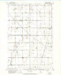
1966 Map of Felton
USGS Topo · Published 1968About this map
Felton serves as the central hub of this Red River Valley landscape, situated along the Great Northern railroad line in Clay County. The 1960s terrain is defined by a meticulous grid of man-made waterways, including County Ditch No 6, County Ditch No 8, and County Ditch No 45, which reveal the intensive engineering required to drain these fertile prairie lands for agriculture. This network of ditches follows the section lines, reinforcing the rigid geometric organization of Viding, Felton, Morken, and Flowing townships.
Find a feature on this map
15 named features on this map. Tap any name to fly to it.
Don’t see what you’re looking for? This feature index may not catch every label — zoom into the map to look around manually.
Map Details
Editions of this 1966 Felton Map
This is the sole edition of this map. No revisions or reprints were ever made.
Other maps of this area

1895 · Fargo
USGS Topo · 1:125,000

1897 · Fargo
USGS Topo · 1:125,000

1918 · Ulen
USGS Topo · 1:62,500

1919 · Hawley
USGS Topo · 1:62,500

1952 · Grand Forks
USGS Topo · 1:250,000

1953 · Fargo
USGS Topo · 1:250,000

1956 · Fargo
USGS Topo · 1:250,000

1956 · Grand Forks
USGS Topo · 1:250,000

1964 · Dilworth
USGS Topo · 1:24,000
1964 · Glyndon North
USGS Topo · 1:24,000